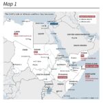
The extended border between the Central African Republic and Sudan (Darfur) represents one of the most volatile security vulnerabilities on the African continent. Across hundreds of kilometers of remote, sparsely populated terrain, traditional trade routes intertwine with smuggling corridors and the movements of armed groups, within a region suffering from a weak state presence and severe security oversight challenges.


During the war in Sudan, this area transformed into a strategic nexus linking Central Africa to the Darfur region, leveraging a vast network of unpaved roads, desert tracks, and seasonal pastoral routes that are nearly impossible to fully control.
The Bangui – Bria – Ndélé – Birao Axis
The primary route originates from the capital, Bangui, heading northeast through a chain of vital towns and hubs:

  • Sibut
  • Kaga-Bandoro
  • Ndélé
  • Bria
  • Sam Ouandja
  • Birao
    This axis serves as the backbone of domestic commercial movement, connecting the capital to the resource-rich northeastern regions. Furthermore, Birao stands as the last major urban center before the Sudanese border, making it an essential logistical staging post for the movement of goods and travelers.
    It is worth noting that this route is used to transport gold extracted from artisanal mines scattered around Bria and Sam Ouandja, in addition to fuel, food supplies, and commercial equipment bound for the border regions.
    The Birao – Karkar – Tissi – Am Dafok Axis
    Beyond Birao, the nature of the terrain shifts completely, turning into unpaved desert tracks crossing virtually uninhabited areas.
    This axis passes through:
  • Toulous
  • Karkar
  • Tissi
  • Am Dafok
    Karkar emerges as one of the most critical transit points in northeastern Central African Republic, serving as an intersection for pastoral migrations, trade, and routes leading to the Sudanese border.
    Meanwhile, Am Dafok serves as the primary gateway to Darfur, linking the Central African Republic to South and West Darfur, and constitutes a strategic chokepoint for the cross-border movement of commodities and individuals.
    The Northern Vakaga Axis
    Within the Vakaga prefecture, a complex network of seasonal tracks and small villages proliferates, most notably:
  • Birao
  • Tissi
  • Karkar
  • Am Sisi
  • Am Dafok
    Movement in these areas relies heavily on four-wheel-drive (4WD) vehicles, motorcycles, and livestock caravans, due to the complete absence of modern infrastructure and the ruggedness of the terrain. These secondary bypass routes allow traffickers to circumvent official checkpoints, making them highly favored by smugglers and informal trade networks.
    Wadis and Seasonal Watercourses
    Wadis (ephemeral riverbeds) play a significant role in mobility across northern Central African Republic, frequently serving as natural corridors away from primary roads.
    Most notable among these are:
  • Wadi Bao
  • Wadi Vakaga
  • Tributaries of the Kotto River
  • Seasonal watercourses extending north of Birao
    During the dry season, segments of these riverbeds transform into natural highways, facilitating seamless movement between villages and border areas.
    What Flows Through These Corridors?
    Gold
    Gold constitutes the most high-value commodity in the region. Artisanal mining sites are concentrated around Bria, Sam Ouandja, and northern Vakaga, from which a portion of the output is funneled through informal networks into Sudan and Chad before reaching regional and international markets.
    Diamonds
    The routes connecting Bria, Ndélé, and Birao are utilized to transport rough diamonds extracted from local mines. A fraction of this production is traded outside official channels via cross-border brokerage and trafficking networks.
    Fuel and Logistical Equipment
    Significant volumes of fuel, spare parts, tires, lubricants, and communication equipment are transported along the Am Dafok – Birao axis to supply mining zones, local markets, and remote outposts.
    Weapons and Ammunition
    Field sources indicate that certain desert tracks stretching between Karkar, Tissi, and Am Dafok are exploited for trafficking light weapons and ammunition between various conflict theaters, taking advantage of the porous and open nature of the border.
    Livestock
    The trade of cattle, camels, and sheep represents one of the most vital economic activities in the region. Pastoralist caravans regularly cross between the Central African Republic and Darfur; however, local sources indicate that certain networks exploit this movement to smuggle livestock or liquidate stolen animals.
    Movement of Individuals
    These corridors are also utilized by herders, traders, seasonal laborers, and displaced persons (IDPs). Additionally, security reports highlight the use of certain border routes for the transit of armed elements and foreign fighters between regional states.
    Mining Zones: The Heart of the Informal Economy
    The most critical gold and mineral sites are concentrated around:
  • Bria
  • Ndélé
  • Sam Ouandja
  • Northern Vakaga
    The proliferation of these mines has fostered a parallel economy dependent on private transport networks, local merchants, and transnational brokers, turning the region into a magnet for various economic and security actors.
    Military and Security Presence
    Despite the limited deployment of government forces in northern Central African Republic, the region witnesses a presence of UN peacekeeping forces (MINUSCA), alongside elements belonging to the Russian “Africa Corps” at certain strategic chokepoints leading to Birao and Am Dafok. While these forces attempt to monitor key transit routes, the rugged geography and the vast expanses of the borderlands render comprehensive control exceptionally difficult.
    Conclusion
    The map of border corridors between the Central African Republic and Darfur reveals an extensive network of tracks and routes linking Bangui to Bria, Ndélé, Sam Ouandja, and Birao, before branching out toward Karkar, Tissi, and Am Dafok into Darfur.
    The significance of these corridors extends far beyond traditional trade; it encompasses the illicit flow of gold, diamonds, fuel, livestock, and individuals, alongside various smuggling activities that capitalize on border porosity and weak state authority.
    While these routes serve as a vital economic lifeline for the local population, they simultaneously pose a profound security challenge for regional governments and international forces operating in one of the most complex landscapes on the African continent.

  • Prepared by: Hassan Youssef Zarma